Google Earth is a computer program that renders a 3D representation of Earth based on satellite imagery, aerial, photography, and geographic information system (GIS) data. Users can explore the globe by entering addresses and coordinates, or by using a keyboard and mouse. It is also available for smartphones and tablets. Users may use the program to add their data using Keyhole Markup Language and upload them through blogs, forums, or other means.
In addition to Earth navigation, Google Earth provides a series of other tools through its desktop application. Additional globes are available for the Moon, Mars, and night sky. A flight simulator is also included as an easter egg.
History[]
Imagery[]
Outer space[]
Google Sky[]
Google Moon[]
Google Mars[]
Miscellaneous features[]
Flight simulator[]
Versions[]
Google Earth Pro[]
Google Earth Pro was originally the business-oriented upgrade to Google Earth, with features such as a movie maker and data importer. Up until late January 2015, it was available for $399/year, though Google decided to make it free to the public.[1][2] Google Earth Pro is currently the standard version of the Google Earth desktop application as of version 7.3.[3] The Pro version includes add-on software for movie making, advanced printing, and precise measurements, and is currently available for Windows, Mac OS X 10.8 or later, and Linux.[4] Oddly, most of the Earth, roads, and country names were outdated.
Google Earth Plus[]
Google Earth Enterprise[]
Google Earth 9[]
Google Earth Plug-in[]
Google Earth VR[]
On November 16, 2016, Google released a virtual reality version of Google Earth for the Steam computer gaming platform. It is currently compatible with the Oculus Rift and HTC Vive virtual reality headsets, allowing users to navigate using VR controllers. Street View support was added on September 14, 2017.
External links[]
Uses[]
Google Earth is useful for many day-to-day and other purposes.
- Google Earth can be used to view areas subjected to widespread disasters if Google supplies up-to-date images. For example after the January 12, 2010 Haiti earthquake images of Haiti were made available on January 17.
- With Google's push for the inclusion of Google Earth in the Classroom,[5] teachers are adopting Google Earth in the classroom for lesson planning, such as teaching students geographical themes (location, culture, characteristics, human interaction, and movement)[6] to creating mashups with other web applications such as Wikipedia.[5][6]
- One can explore and place location bookmarks on the Moon, and Mars.
- One can also get directions using Google Earth, using variables such as street names, cities, and establishments.
- Google Earth can also function as a hub of knowledge, pertaining the users location. By enabling certain options, one can see the location of gas stations, restaurants, museums, and other public establishments in their area. Google Earth can also dot the map with links to images, YouTube videos, and Wikipedia articles relevant to the area being viewed.
Features[]
Wikipedia and Panoramio integration[]
In December 2006, Google Earth added a new layer called "Geographic Web" that includes integration with Wikipedia and Panoramio. In Wikipedia, entries are scraped for coordinates via the Template:Srlink. There is also a community-layer from the project Wikipedia-World. More coordinates are used, different types are in the display and different languages are supported than the built-in Wikipedia layer.[7][8] Google announced on May 30, 2007 that it is acquiring Panoramio.[9] In March 2010, Google removed the "Geographic Web" layer. The "Panoramio" layer became part of the main layers and the "Wikipedia" layer was placed in the "More" layer.
Flight simulator[]
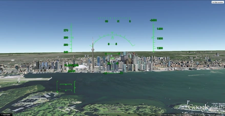
Downtown Toronto, as seen from a F16 Fighting Falcon during a simulated flight.
In Google Earth v4.2 a flight simulator was included as a hidden feature. Starting with v4.3 it is no longer hidden. Initially the F-16 Fighting Falcon and the Cirrus SR-22 were the only aircraft available, and they could be used with only a few airports. In addition to keyboard control, the simulator can be controlled with a mouse or joystick.[citation needed] Google Earth v5.1 and higher crashes when starting flight simulator with Saitek and other joysticks. The user can also fly underwater.
Featured planes[]
- F-16 Fighting Falcon – A much higher speed and maximum altitude than the Cirrus SR-22, it has the ability to fly at a maximum speed of Mach 2, although a maximum speed of 1678 knots (3107 km/h) can be achieved. The take-off speed is 225 knots, the landing speed is 200 knots (370 km/h).
- Cirrus SR-22 – Although slower and with a lower maximum altitude, the SR-22 is much easier to handle and is preferred for up-close viewing of Google Earth's imagery. The take-off speed is 75 knots (139 km/h), the landing speed is 70 knots ()[10]
The flight simulator can be commanded with the keyboard, mouse or plugged-in joystick. Broadband connection and a high speed computer provides a very realistic experience.[11] The simulator also runs with animation, allowing objects (for example: planes])[12] to animate while on the simulator. Image overlays[13] can also be added to make it look like the cockpit of a plane.
Sky mode[]
Main article: Google Sky
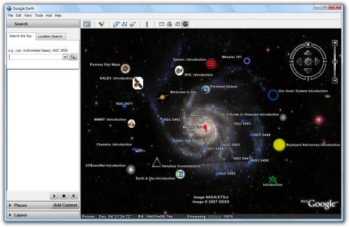
Google Earth in Sky Viewing Mode
Google Sky is a feature that was introduced in Google Earth 4.2 on August 22, 2007, and allows users to view stars and other celestial bodies.[14] It was produced by Google through a partnership with the Space Telescope Science Institute (STScI) in Baltimore, the science operations center for the Hubble Space Telescope. Dr. Alberto Conti and his co-developer Dr. Carol Christian of STScI plan to add the public images from 2007,[15] as well as color images of all of the archived data from Hubble's Advanced Camera for Surveys. Newly released Hubble pictures will be added to the Google Sky program as soon as they are issued. New features such as multi-wavelength data, positions of major satellites and their orbits as well as educational resources will be provided to the Google Earth community and also through Christian and Conti's website for Sky.[16] Also visible on Sky mode are constellations, stars, galaxies and animations depicting the planets in their orbits. A real-time Google Sky mashup of recent astronomical transients, using the VOEvent protocol, is being provided by the VOEventNet[17] collaboration. Google's Earth maps are being updated each 5 minutes.
Google Sky faces competition[18] from Microsoft WorldWide Telescope (which runs only under the Microsoft Windows operating systems) and from Stellarium, a free open source planetarium that runs under Microsoft Windows, Mac OS X, and Linux.
On March 13, 2008, Google made a web-based version[19] of Google Sky available via the internet.
Street View[]
Main article: Google Street View On April 15, 2008 with version 4.3, Google fully integrated its Street View into Google Earth. In version 6.0, the photo zooming function has been removed because it is incompatible with the new 'seamless' navigation.
Google Street View provides 360° panoramic street-level views and allows users to view parts of selected cities and their surrounding metropolitan areas at ground level. When it was launched on May 25, 2007 for Google Maps, only five cities were included. It has since expanded to more than 40 U.S. cities, and includes the suburbs of many, and in some cases, other nearby cities. Recent updates have now implemented Street View in most of the major cities of Australia and New Zealand as well as parts of Canada, parts of South Africa, Denmark, Mexico, Japan, Norway, Finland, Spain, Sweden, France, the UK, Republic of Ireland, the Netherlands, Italy, Switzerland, Portugal, Taiwan, and Singapore.
Google Street View, when operated, displays photos that were previously taken by a camera mounted on an automobile, and can be navigated by using the mouse to click on photograph icons displayed on the screen in the user's direction of travel. Using these devices, the photos can be viewed in different sizes, from any direction, and from a variety of angles.
Water and ocean[]
Introduced in version 5.0 (February 2009), the Google Ocean feature allows users to zoom below the surface of the ocean and view the 3D bathymetry beneath the waves. Supporting over 20 content layers, it contains information from leading scientists and oceanographers.[20] On April 14, 2009, Google added underwater terrain data for the Great Lakes.[21] In 2010, Google added underwater terrain data for Lake Baikal.
In June 2011, higher resolution of some deep ocean floor areas increased in focus from 1-kilometer grids to 100 meters thanks to a new synthesis of seafloor topography released through Google Earth.[22] The high resolution features were developed by oceanographers at Columbia University’s Lamont-Doherty Earth Observatory from scientific data collected on research cruises. The sharper focus is available for about 5 percent of the oceans (an area larger than North America). Underwater scenery can be seen of the Hudson Canyon off New York City, the Wini Seamount near Hawaii, and the sharp-edged 10,000-foot-high Mendocino Ridge off the U.S Pacific Coast. There is a Google 2011 Seafloor Tour for those interested in viewing ocean deep terrain.
Historical Imagery[]
Introduced in version 5.0, Historical Imagery allows users to traverse back in time and study earlier stages of any place. This feature allows research that require analysis of past records of various places.[23]
A side-by-side comparison of The Ziggurat and Raley Field in West Sacramento, California from 1993 on the left and 2009 on the right. As shown in the 1993 side both the Ziggurat and Raley Field do not exist.
Mars[]
Main article: Google Mars Google Earth 5 includes a separate globe of the planet Mars, that can be viewed and analysed for research purposes. The maps are of a much higher resolution than those on the browser version of Google Mars and it also includes 3D renderings of the Martian terrain. There are also some extremely high resolution images from the Mars Reconnaissance Orbiter's HiRISE camera that are of a similar resolution to those of the cities on Earth. Finally, there are many high resolution panoramic images from various Mars landers, such as the Mars Exploration Rovers, Spirit and Opportunity, that can be viewed in a similar way to Google Street View. Interestingly enough, layers on Google Earth (such as World Population Density) can also be applied to Mars. Layers of Mars can also be applied onto Earth. Mars also has a small application found near the face on Mars. It is called Meliza, and features a chat between the user and an automatic robot speaker. It is useful for research on Mars, but is not recommended for normal conversations.
Moon[]
Main article: Google Moon
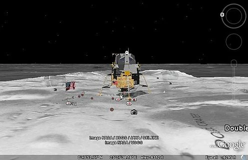
One of the lunar landers viewed in Google Moon
On July 20, 2009, the 40th anniversary of the Apollo 11 mission, Google introduced the Google Earth version of Google Moon,[24] which allows users to view satellite images of the Moon. It was announced and demonstrated to a group of invited guests by Google along with Buzz Aldrin at the Newseum in Washington, D.C.[25][26]
Google Earth Engine[]
Google Earth Engine is a separate product, not a part of Google Earth.
Liquid Galaxy[]
Liquid Galaxy is a cluster of computers running Google Earth creating an immersive experience. It began as a Google 20% project by Google engineers. On September 30, 2010, Google made the configuration and schematics for their rigs public,[27] placing code and setup guides on the Liquid Galaxy wiki.[28]
Influences[]
Google Earth can be traced directly back to a small company named Autometric, now a part of Boeing. A team at Autometric, led by Robert Cowling, created a visualization product named Edge Whole Earth. Bob demonstrated Edge to Michael T. Jones. Chris Tanner, and others at SGI in 1996. Several other visualization products using imagery existed at the time, including Performer-based ones, but Michael T. Jones stated emphatically that he had "never thought of the complexities of rendering an entire globe..." The catch phrase "from outer space to in your face" was coined by Autometric President Dan Gordon, and used to explain his concept for personal/local/global range. Edge blazed a trail as well in broadcasting, being used in 1997 on CBS News with Dan Rather, in print for rendering large images draped over terrain for National Geographic, and used for special effects in the feature film Shadow Conspiracy in 1997. In 2000, Edge Viewer was made available through the National Geospatial-Intelligence Agency for free.
Gordon was a huge fan of the ‘Earth’ program described in Neal Stephenson's sci-fi classic Snow Crash. Indeed, a Google Earth co-founder claimed that Google Earth was modeled after Snow Crash,[29] while another co-founder said it was inspired by the short science education film Powers of Ten.[30] In fact Google Earth was at least partly inspired by a Silicon Graphics demo called "From Outer Space to in Your Face" which zoomed from space into the Swiss Alps then into the Matterhorn.[31] This launch demo was hosted by an Onyx 3000 with InfiniteReality4[32] graphics, which supported Clip Mapping and was inspired by the hardware texture paging capability (although it did not use the Clip Mapping) and "Powers of Ten". The first Google Earth implementation called Earth Viewer emerged from Intrinsic Graphics as a demonstration of Chris Tanner's software based implementation of a Clip Mapping texture paging system and was spun off as Keyhole Inc. Earth Viewer was the inevitable ultimate realization of the capabilities of a seamless texture paging system and many of the individuals working on Earth Viewer were Silicon Graphics alumni.
Technical specifications[]
Detailed release notes/history/changelog are made available by Google.[33]
Imagery and coordination[]
- Coordinate System and Projection
- The internal coordinate system of Google Earth is geographic coordinates (latitude/longitude) on the World Geodetic System of 1984 (WGS84) datum.
- Google Earth shows the earth as it looks from an elevated platform such as an airplane or orbiting satellite. The projection used to achieve this effect is called the General Perspective. This is similar to the Orthographic projection, except that the point of perspective is a finite (near earth) distance rather than an infinite (deep space) distance.
- Baseline resolutions
- Czech Republic: 0.1 - 0.5 m (by Eurosense / Geodis Brno)
- Slovakia: 0.5 m (by Eurosense / Geodis Slovakia)
- Hungary: 2.5 m SPOT Images. Budapest approx. 0,3 m.
- Germany, Switzerland, Netherlands, Denmark, UK, Andorra, Luxembourg, Liechtenstein, San Marino, Vatican City: 1 m or better
- Balkans: 2.5 m (medium resolution)
- U.S.: 1 m (excludes Alaska & Hawaii)
- Global: Generally 15 m (some areas, such as Antarctica, are in extremely low resolution), but this depends on the quality of the satellite/aerial photograph uploaded.
- Typical high resolutions
- Europe: 0.3 m, 0.15 m (e.g. Berlin, Zurich, Hamburg), 0.1 m Prague
- U.S.: 1 m, 0.6 m, 0.3 m, 0.15 m (extremely rare; e.g. Cambridge and Google Campus, or Glendale)
- Altitude resolution:
- Surface: varies by country
- Seabed: Not previously applicable, but since the introduction of "Ocean", elevation data has been introduced (a colorscale approximating sea floor depth is "printed" on the spherical surface at views from high altitudes).
- Age: Images dates vary. The image data can be seen from squares made when DigitalGlobe Coverage is enabled. The date next to the copyright information is not the correct image date. Zooming in or out could change the date of the pictures. Most of the international urban image dates are from 2004 and have not been updated. However, most US images are kept current. Google announces imagery updates on their LatLong Blog[34] in form of a quiz, with hints of the updated locations. The answers are posted some days later in the same blog.
Hardware and software[]
Google Earth is unlikely to operate on older hardware configurations. The most recent system requirements update[35] document these minimum configurations:
- Pentium 3, 500MHz
- 256 Megabytes of RAM
- 400 MB free disk space
- Network speed: 128 kbit/s
- 64MB DirectX9 and 3D capable graphics card
- Resolution of 1024x768, 16-bit High Color - DirectX 9 (to run in Direct X mode)
- Windows 2000, Windows XP, Windows Vista, Windows 7, Linux or Mac OS X
The most likely cause of failure is insufficient video RAM: the software is designed to warn the user if their graphics card is not able to support Earth (this often occurs due to insufficient Video RAM or buggy graphics card drivers). The next most likely mode of failure is Internet access speed. Fast broadband Internet (Cable, DSL, T1, etc.) is required.
Linux specifications[]
- Minimum System Requirements
- [36]
- Kernel: 2.4 or later
- CPU: Pentium III, 500 MHz
- System Memory (RAM): 128 MB
- Hard Disk: 400 MB free space
- Network Speed: 128 kbit/s
- Screen: 1024x768, 16 bit color
- Tested and works on the following distributions:
- Ubuntu 5.10 or later
- SUSE 10.1 or later
- Fedora Core 4 or later
- Linspire 5.1
- Gentoo 2006.0
- Debian 3.1/4
- Red Hat 9
- Slackware 11.0
- FreeBSD 6.1/7.0 with Linux Emulation
- Arch Linux 0.7.2 Duke
- Xandros 3.0.3 Business Edition
- Mandriva 2007
- Sabayon Linux 3.26
- PCLinuxOS 5.0
- PC/OS 7.10
Web browsing[]
As of Google Earth 5, the contents of description balloons, which are created in KML using JavaScript and iFrames, are rendered with an embedded WebKit engine.[37]
Versions and variations[]
Release timeline[]
Illustrates timeline of KML and Google Earth history
- Keyhole Earthviewer 1.0 - June 11, 2001
- Keyhole Earthviewer 1.3 - January 1, 2002
- Keyhole Earthviewer 1.7 - February 2002
- Keyhole LT 1.7.1 - August 26, 2003
- Keyhole NV 1.7.2 - October 16, 2003
- Keyhole 2.2 - August 19, 2004
- GOOGLE UNIVERSE 1.0 - January 2005
- Google Earth 3.0 - June 28, 2005
- Google Earth 4.0 - June 11, 2006
- Google Earth 4.1 - May 29, 2007
- Google Earth 4.2 - August 23, 2007
- Google Earth 4.3 - April 15, 2008
- Google Earth 5.0 - May 5, 2009
- Google Earth 5.1 - November 18, 2009
- Google Earth 5.2 - July 1, 2010
- Google Earth 6.0 - March 29, 2011
- Google Earth 6.1 - October 21, 2011
- Google Earth 6.2 - January 26, 2012 (beta)
Mac version[]
A version for Mac OS X was released on January 10, 2006, and is available for download from the Google Earth website. With a few exceptions noted below, the Mac version appears to be stable and complete, with virtually all the same functionality as the original Windows version.
Screenshots and an actual binary of the Mac version had been leaked to the Internet on December 8, 2005. The leaked version was significantly incomplete. Among other things, neither the Help menu nor its "Display License" feature worked, indicating that this version was intended for Google's internal use only. Google released no statement regarding the leak.
The Mac version runs only under Mac OS X version 10.4 or later. There is no embedded browser, no direct interface to Gmail and no full screen option. As of January 2009 there are a few bugs concerning the menu bar when switching between applications and a few bugs concerning annotation balloons and printing.
From version 4.1.7076.4558 (released on May 9, 2007) onward Mac OS X users can, among other new features, upgrade to the "Plus" version via an option in the Google Earth menu.[38] Some users reported difficulties with Google Earth crashing in the then current version when zooming in.[39]
Linux version[]
Starting with the version 4 beta Google Earth functions under Linux, as a native port using the Qt-toolkit. It is proprietary software specifically in order to impose Digital Rights Management[citation needed]; the Free Software Foundation consider the development of a free compatible client for Google Earth to be a High Priority Free Software Project.[40]
Android version[]
An Android version was released on Monday, February 22, 2010.[41]
iOS version[]
Google Earth iOS version icon
A version for the iOS, which runs on the iPhone, iPod Touch and the iPad, was released for free on the App Store on October 27, 2008.[42][43] It makes use of the multi-touch interface to move on the globe, zoom or rotate the view, and allow to select the current location using the iPhone integrated Assisted GPS. This version, however, does not feature layers like computer versions do. Like Google Maps, it only integrates the Wikipedia and Panoramio layers.[44]
Google Earth Plus[]
Discontinued in December 2008, Google Earth Plus was an individual-oriented paid subscription upgrade to Google Earth that provided customers with the following features, most of which are now available in the free Google Earth:
- GPS integration: read tracks and waypoints from a GPS device. A variety of third party applications have been created which provide this functionality using the basic version of Google Earth by generating KML or KMZ files based on user-specified or user-recorded waypoints. However, Google Earth Plus provides direct support for the Magellan and Garmin product lines, which together hold a large share of the GPS market.
The Linux version of the Google Earth Plus application does not include any GPS functionality. - Higher resolution printing.
- Customer support via email.
- Data importer: read address points from CSV files; limited to 100 points/addresses. A feature allowing path and polygon annotations, which can be exported to KML, was formerly only available to Plus users, but was made free in version 4.0.2416.
- Higher data download speeds
Google Earth Pro[]
For a $399 annual subscription fee, Google Earth Pro is a business-oriented upgrade to Google Earth that has more features than the Plus version. The Pro version includes add-on software such as:
- Movie making.
- GIS data importer.
- Advanced printing modules.
- Radius and area measurements
Originally, these features cost extra in addition to the $399 fee, but more recently[when?] have been included in the package.
The professional version is available for Windows (NT-based versions), Mac OS X 10.4 or later and Linux.[45]
Google Earth Enterprise[]
Google Earth Enterprise is a version of Google Earth designed for use by organizations whose businesses could take advantage of the program's capabilities.[46]
Automotive version[]
An automotive version of Google Earth is available in the 2010 Audi A8.[47]
Google Earth Plug-in[]
The Google Earth API is a free beta service, available for any web site that is free to consumers. The Plug-in and its JavaScript API allows users to place a version of Google Earth into web pages. The API does not have all the features of the full Google Earth Application but enables sophisticated 3D map applications to be built.
The Google Earth Plug-in is currently available for the following web browsers and operating systems:
Microsoft Windows (2000, XP, Vista, and 7)
- Google Chrome 1.0+
- Internet Explorer 6.0+
- Firefox 2.0+
- Flock 1.0+
Apple Mac OS X 10.4 and higher (Intel and PowerPC)
- Safari 3.1+
- Firefox 3.0+
To date the plug-in supports the following layers:
- Terrain
- Roads
- Buildings
- Borders
- 3-D Buildings
It also supports 'Sky Mode', 'Photo Overlays', and provides much of the same controls and information bar as the full application.
Imagery resolution and accuracy[]
The west side of Gibraltar (UK), tilted view showing the sea rising up the Rock of Gibraltar - claimed altitude of the sea just off the beach at Elliots Memorial, 252 m. This is now fixed. Template:Coord
Mount Tamalpais, detail of parcel-scale 40cm-gridded terrain in good registration with 30cm-pixel aerial photo. Template:Coord
Most land areas are covered in satellite imagery with a resolution of about 15 m per pixel. This base imagery is 30m multispectral Landsat which is pansharpened with the 15m [panchromatic] Landsat imagery. However, Google is actively replacing this base imagery with 2.5m SPOTImage imagery and several higher resolution datasets mentioned below. Some population centers are also covered by aircraft imagery (orthophotography) with several pixels per meter. Oceans are covered at a much lower resolution, as are a number of islands; notably, the Isles of Scilly off southwest United Kingdom were at a resolution of about 500 m or less, although this has since been addressed.
Google has resolved many inaccuracies in the vector mapping since the original public release of the software, without requiring an update to the program itself. An example of this was the absence from Google Earth's map boundaries of the Nunavut territory in Canada, a territory that had been created on April 1, 1999; this mistake was corrected by one of the data updates in early 2006. Recent updates have also increased the coverage of detailed aerial photography, particularly in certain areas of western and central Europe.
The images are not all taken at the same time, but are generally current to within three years. However, with the release of Google Earth 5.0, it has historical images dating back to the 1940s in some spots. Image sets are sometimes not correctly stitched together. Updates to the photographic database can occasionally be noticed when drastic changes take place in the appearance of the landscape, for example Google Earth's incomplete updates of New Orleans following Hurricane Katrina, or when placemarks appear to shift unexpectedly across the Earth's surface. Though the placemarks have not in fact moved, the imagery is composed and stitched differently. Such an update to London's photography in early 2006 created shifts of 15–20 metres in many areas, noticeable because the resolution is so high.
Place name and road detail vary greatly from place to place. They are most accurate in North America, Europe and Australia, but regular mapping updates are improving coverage elsewhere.
Errors sometimes occur due to the technology used to measure the height of terrain; for example, tall buildings in Adelaide, Australia, cause one part of the city to be rendered as a small mountain, when it is in fact flat. Also, in Downtown Los Angeles, there is a large hill in the approximate location of Bunker Hill, where many of the skyscrapers are located. The height of the Eiffel Tower creates a similar effect in the rendering of Paris. Also, prior to the release of version 5.0 in February 2009, elevations below sea level were presented as sea level, for example: Salton City, California; Death Valley; and the Dead Sea were all listed as 0 m when Salton City is −38 m, Death Valley −86 m, and the Dead Sea −420 m.
Where no 3 arc second digital elevation data was available, the three dimensional images covering some areas of high relief are not at all accurate, but most mountain areas are now well mapped. The underlying digital elevation model has been placed 3 arc seconds too far north and up to 3 arc seconds too far west. This means that some steep mountain ridges incorrectly appear to have shadows extending over onto their south facing sides. Some high resolution images have also been misplaced: an example is the image covering Annapurna, which is misplaced by about 12 arc seconds. Elevation data was recently[when?] updated to 10-meter (1/3-arc-second) resolution for much of the United States from the previous 30-meter (1-arc-second) resolution.
In some areas, local government jurisdictions have submitted more finely gridded terrain models through the Map Content Partners program.[48] In March 2010, the County of Marin, just north of the Golden Gate Bridge by San Francisco, California, published a 40 cm gridded terrain surface of 1425 km2 through the program.
The "Measure" function shows that the length of equator is about 40,030.24 km, giving an error of −0.112% compared with the actual value of 40,075.02 km Earth; for the meridional circumference, it shows a length of about 39,963.13 km, also giving an error of −0.112% compared with the actual value of 40,007.86 km.
On December 16, 2007, most of Antarctica was updated to a 15 m resolution using imagery from the Landsat Image Mosaic of Antarctica (1 m resolution images of some parts of Antarctica were added in June 2007); however, the Arctic polar ice cap is completely absent from the current version of Google Earth, as are waves in the oceans. The geographic North Pole is found hovering over the Arctic Ocean and the tiling system produces artifacts near the poles as the tiles become 'infinitely' small and rounding errors accumulate.
Cloud cover and shadows can make it difficult or impossible to see details in some land areas, including the shadow side of mountains.
Some parts of the world have still not been photographed. Very low resolution photos or false color photos indicate that the area has not been photographed. On Google Earth 6.0 it is easy to see areas that are not photographed by simply clicking the Historical imagery option on.
Controversy and criticism[]
The software has been criticized by a number of special interest groups, including national officials, as being an invasion of privacy and even posing a threat to national security. The typical argument is that the software provides information about military or other critical installations that could be used by terrorists.
- Former President of India APJ Abdul Kalam expressed concern over the availability of high-resolution pictures of sensitive locations in India.[49] Google subsequently agreed to censor such sites.[50]
- The Indian Space Research Organisation said Google Earth poses a security threat to India, and seeks dialogue with Google officials.[51]
- The South Korean government expressed concern that the software offers images of the presidential palace and various military installations that could possibly be used by hostile neighbor North Korea.[52]
- In 2006, one user spotted a large topographical replica in a remote region of China. The model is a small-scale (1/500) version of the Karakoram Mountain Range, currently under the control of China but claimed by India. When later confirmed as a replica of this region, spectators began entertaining military implications.[53][54]
- In 2006, Google Earth began offering detailed images of classified areas in Israel. The images showed Israel Defense Forces bases, including secret Israeli Air Force facilities, Israel's Arrow missile defense system, military headquarters and Defense Ministry compound in Tel Aviv, a top-secret power station near Ashkelon, and the Negev Nuclear Research Center. Also shown was the alleged headquarters of the Mossad, Israel's foreign intelligence service, whose location is highly classified.[55][56]
- Operators of the Lucas Heights nuclear reactor in Sydney, New South Wales, Australia asked Google to censor high resolution pictures of the facility.[57] However, they later withdrew the request.[58]
- In July 2007, it was reported that a new Chinese Navy Jin-class nuclear ballistic missile submarine was photographed at the Xiaopingdao Submarine Base south of Dalian.[59]
- Hamas and the al-Aqsa Martyrs' Brigades have reportedly used Google Earth to plan Qassam rocket attacks on Israel from Gaza (See: List of Qassam rocket attacks.)[60][61]
- The lone surviving gunman involved in the 2008 Mumbai attacks admitted to using Google Earth to familiarise himself with the locations of buildings used in the attacks.[62]
- Michael Finton, aka Talib Islam, used Google Earth in planning his attempted September 24, 2009, bombing of the Paul Findley Federal Building and the adjacent offices of Congressman Aaron Schock in Springfield, Illinois.[63]
- In 2009, Google superimposed old woodblock prints of maps from 18th and 19th century Japan over Japan today. These maps marked areas inhabited by the burakumin caste, who were considered "non-humans" for their "dirty" occupations, including leather tanning and butchery. Descendants of members of the burakumin caste still face discrimination today and many Japanese people feared that some would use these areas, labeled etamura (穢多村, translation: "village of an abundance of defilement""), to target current inhabitants of them. These maps are still visible on Google Earth, but with the label removed where necessary.[64]
- Thieves in the United Kingdom allegedly use Google Earth to find Church of England churches with lead roofs in order to steal the lead and sell it as scrap (at $2,400 per metric tonne) on the metals market.[65]
| Country | By Whom | Reason | Since When | Source |
|---|---|---|---|---|
| Iran | US government export restrictions | 2007 | [66] | |
| Morocco | Maroc Telecom, the most popular service provider | Unknown | 2006 | [67] |
| Sudan | US government export restrictions | 2007 | [68] |
Blurred out image of the Royal Stables in The Hague, Netherlands. This has since been partially lifted.
Some citizens may express concerns over aerial information depicting their properties and residences being disseminated freely. As relatively few jurisdictions actually guarantee the individual's right to privacy, as opposed to the state's right to secrecy, this is an evolving point. Perhaps aware of these critiques,[69] for a time, Google had Area 51 (which is highly visible and easy to find) in Nevada as a default placemark when Google Earth is first installed.
As a result of pressure from the United States government, the residence of the Vice President at Number One Observatory Circle was obscured through pixelization in Google Earth and Google Maps in 2006, but has since been lifted. The usefulness of this downgrade is questionable, as high-resolution photos and aerial surveys of the property are readily available on the Internet elsewhere.[70] Capitol Hill used to also be pixelized in this way, but this was lifted. The Royal Stables in The Hague, Netherlands used to be pixelized as well, but was partially lifted. If one zooms in too close to the Stables, it is still pixelized.
Critics have expressed concern over the willingness of Google to cripple their dataset to cater to special interests, believing that intentionally obscuring any land goes against its stated goal of letting the user "point and zoom to any place on the planet that you want to explore".[71]
In the United Kingdom, critics have also argued that Google Earth has led to the vandalism of private property, highlighting the graffiti of a penis being drawn on the roof of a house near Hungerford,[72] on the roof of Yarm School at Stockton on Tees[73] and on the playing fields of a school in Southampton[74] as examples of this.
In Hazleton, Pennsylvania, media attention and critics focused on Google Earth once more because of the defacing of the Hazleton Area Highschool Football field. Grass was removed to create the image of a penis approximately 35 yards long and 20 yards wide.[75]
Recent versions of Google Earth require a software component running in the background that will automatically download and install updates. Several users expressed concerns that there is not an easy way to disable this updater, as it currently runs without the permission of the user.[76]Template:Dubious
Copyright[]
Currently, every image created from Google Earth using satellite data provided by Google Earth is a copyrighted map. Any derivative from Google Earth is made from copyrighted data which, under United States Copyright Law, may not be used except under the licenses Google provides. Google allows non-commercial personal use of the images (e.g. on a personal website or blog) as long as copyrights and attributions are preserved.[77] By contrast, images created with NASA's globe software World Wind use The Blue Marble, Landsat or USGS layer, each of which is a terrain layer in the public domain. Works created by an agency of the United States government are public domain at the moment of creation. This means that those images can be freely modified, redistributed and used for commercial purposes.
Layers[]
Google Earth also features many layers as a source for information on businesses and points of interest, as well as showcasing the contents of many communities, such as Wikipedia, Panoramio and YouTube. Google updates with new layers often. Many Google Earth layers, such as Panoramio and Google Earth Community layers, are updated daily with entries from the respective websites.
Borders and labels[]
Contains borders for countries/provinces and shows placemarks for cities and towns.
- Borders: Marks international borders with a thick yellow line, 1st level administrative borders (generally provinces and states) with a lavender line, and 2nd level administrative borders (counties) with a cyan line. Coastlines appear as a thin yellow line. Displays names of countries, 1st level administrative areas, and islands.
- Labels: Displays labels for large bodies of water, such as oceans, seas, and bays, and populated places.
Places of interest[]
A collection of business listings provided by many local services.
Panoramio[]
Shows many of the most relevant pictures uploaded onto Panoramio's website.
Roads[]
Displays available road networks. The colors and signs displayed vary depending on the type of roadway.
- Limited-access freeways and tollways that are part of widespread networks such as the International E-road network, United States Interstate Highways and many other national road networks are represented by orange lines.
- Other freeways are marked with pale orange lines.
- Some roads in Japan are indigo.
- Other important roads, generally those most travelled, highest capacity, or bearing a road number, are labeled with yellow lines.
- All other roads are labeled white.
- Some pedestrian walkways and private roads are signified by transparent white lines, especially when greatly resembling a road intended for public automotive traffic.
Buildings in 3D[]
Shows many 3D computer building models in many cities, in these styles:
- Photorealistic: Shows many buildings in a realistic style, with more complex polygons and surface images.
- Gray: Low-detail models of city buildings designed for computers that may not have the capability of showing the photorealistic models.
Any real world building can be created for Google Earth via a number of avenues:
- Users can create their own 3D buildings with Building Maker. This browser based tool allows users to match 'boxes' to aerial imagery of certain cities. Low learning curve resulting in lower quality 3D buildings.
- Users can download SketchUp a 3D modeling application that allows users to create detailed digital representations of real world buildings. Provided the models meet Google's criteria, they can then be uploaded to the 3D warehouse and accepted to Google Earth
- There are now several companies, certified by Google,[78] that provide a service creating and maintaining 3D buildings for customers. These companies generally provide high detail models.
In 2009, in a unique collaboration between Google and the Museo del Prado in Madrid, the museum selected 14 of its most important paintings to be photographed and displayed at the ultrahigh resolution of 14,000 megapixels inside the 3D version of the Prado in Google Earth and Google Maps.[79][80]
Google Street View[]
Main article: Google Street View Shows placemarks with 360 degree panoramic views of streets of many cities in Australia, France, the United Kingdom, Republic of Ireland, Italy, Japan, New Zealand, Spain, the United States, and recently[when?] Portugal, Brazil, the Netherlands, Taiwan, Switzerland, Canada, Mexico, Sweden, Norway, South Africa and Finland.
Weather[]
- Clouds - Displays cloud cover based on data from both geostationary and low Earth-orbiting satellites. The clouds appear at their calculated elevation, determined by measuring the cloud top temperature relative to surface temperature.[81]
- Radar - Displays weather radar data provided by weather.com and Weather Services International, updating every 5–6 minutes.[81]
- Conditions and Forecast - Displays local temperatures and weather conditions. Clicking on an indicator displays a 2 Day Forecast (Example: Monday Morning, Monday Night, Tuesday Morning, Tuesday Night) forecast provided by weather.com.[81]
- Information - Clicking Information allows users to further read up on where Google Earth gets weather information.[81]
Gallery[]
- Ancient Rome: Launched by Google on November 12, 2008.
- Discovery Networks: Shows geographical information from the Discovery Channel.
- European Space Agency: Shows many satellite images taken of Earth.
- Gigapan Photos: Images from Google's Gigapan project.
- Gigapxl Photos: Photographs taken using Gigapxl.
- Google Book Search: An application of the Google Book search in Google Earth.
- Google Earth Community: User developed content hosted on Google's official Google Earth Community Forum.
- Google News: Shows news stories from many worldwide news sources.
- NASA: A showcase of many satellite images, overlays and features from NASA.
- National Geographic magazine: Shows many features from the National Geographic Magazine.
- New York Times: A collection of news stories from the popular New York City newspaper.
- Rumsey Historical Maps: Shows a collection of historic maps, dating back to the 1600s.
- Travel and Tourism
- 100% Pure New Zealand
- Egypt Tourism
- Japan Tourism
- Korea Tourism
- Kyoto Tourism
- South Africa Tourism
- Turn Here: City Video Guides
- Walt Disney World Resort
- Trimble Outdoor Trips: A collection of hiking trails with recordings.
- Volcanoes
- Webcams.travel: A collection of webcams around the world
- YouTube: A collection of popular videos on YouTube.
Global awareness[]
A collection of services spreading global awareness. The layer was provided by Google Earth Outreach.
- Appalachian Mountaintop removal
- ARKive: Endangered species
- Earthwatch Expeditions
- Fair Trade Certified
- Global Heritage Fund
- Greenpeace
- Jane Goodall's Gombe Chimpanzee Blog
- The Earth from Above with Goodplanet
- The Elders: Every Human Has Rights
- UNDP: Millennium Development Goals Monitor
- UNEP: Atlas of our Changing Environment
- Unicef: Water and Sanitation
- USHMM: World is Witness
- War in Darfur
- WaterAid
- WWF Conservation Projects
Ocean[]
- Animal Tracking
- ARKive: Endangered Ocean Species
- BBC Earth
- Census of Marine Life
- Cousteau Ocean World
- Explore the Ocean
- Marine Protected Area[82]
- National Geographic
- Magazine Quiz
- Ocean Atlas
- Ocean Expeditions
- Ocean Sports
- Dive Spots
- Kite Surfing Spots
- Surf Spots
- Shipwrecks
- State of the Ocean
- Marie Tharp Historical Map
- Underwater Features
Sky layers[]
Layers for Google Sky.
- Welcome to Sky: An introduction to the Sky mode.
- Current Sky Events
- EarthSky Podcasts[83]
- Hubblecast
- StarDate by the University of Texas
- VOEventNET
- Our Solar System: Shows locations, orbits and information of the Solar System.
- Backyard Astronomy: Shows information about constellations and other space sights visible from a backyard telescope.
- Featured Observatories
- Hubble Showcase
- Spitzer Infrared Showcase
- GALEX Ultraviolet Showcase
- Chandra X-Ray Showcase
- WMAP Microwave Showcase
- IRAS Infrared Sky
- Education Center
- Celestron SkyScout Audio
- Virtual Tourism
- User's Guide to Galaxies
- Life of a Star
- Historical Sky Maps
- Rumsey Star Maps
- Hevelius Constellations
- Sky Community: Posted KML files in the Sky forum in the Google Earth Community.
Mars layers[]
- Featured Satellite Images
- Global Maps
- Place Names
- Mars Gallery
- A Traveler's Guide to Mars
- Rovers and Landers
- Spacecraft Imagery
References[]
- ↑ Kate Knibbs (February 2, 2015). "Google Earth Pro Is Now Available for Free". https://gizmodo.com/google-earth-pro-is-now-free-1682987518.
- ↑ Rose, Robert (February 11, 2015). "Good News Everyone! Google Earth Pro Now Free!". http://mapshole.com/2015/02/11/google-earth-pro-now-free/. Retrieved February 22, 2015.
- ↑ Google (July 10, 2017). "notes on Google Earth releases". http://earth.google.com/support/bin/answer.py?hl=en&answer=40901.
- ↑ "Google Earth for Desktop". https://www.google.com/earth/explore/products/desktop.html. Retrieved February 22, 2015.
- ↑ 5.0 5.1 Natasha Wyatt. "Reinventing classroom geography with Google Earth API". Google Earth and Maps team. http://googleenterprise.blogspot.com/2010/04/reinventing-classroom-geography-with.html. Retrieved 2010-04-29.
- ↑ 6.0 6.1 Karen Ganzel (2010-04-27). "Geography Lesson Plans Using Google Earth". Lesson Planet. http://www.lessonplanet.com/directory_articles/elementary_math_lesson_plans/27_April_2010/337/geography_lesson_plans_using_google_earth. Retrieved 2010-04-29.
- ↑ http://tools.wikimedia.de/~kolossos/world-link.php?lang=en dynamic
- ↑ http://www.webkuehn.de/hobbys/wikipedia/geokoordinaten/index.htm
- ↑ "Google is planning to acquire Panoramio". google.com. http://www.google.com/intl/en/press/annc/annc_panoramio.html.
- ↑ [1][dead link]
- ↑ Webwise: Google's flight simulator The Sunday Times, January 27, 2008
- ↑ http://www.gearthblog.com/blog/archives/2009/08/planes_for_google_earth_flight_simu.html
- ↑ http://www.gearthhacks.com/dlfile31271/Airbus-A400--Flight-Sim-Overlay.htm
- ↑ "Explore the sky with Google Earth". Google. 2007-08-22. http://earth.google.com/sky/skyedu.html. Retrieved 2007-08-22.
- ↑ "Celestial add-on points Google Earth at the stars - tech - August 22, 2007 - New Scientist Tech". Technology.newscientist.com. http://technology.newscientist.com/article/dn12523. Retrieved 2010-08-25.
- ↑ http://hubblesite.org/explore_astronomy/gsky/
- ↑ http://voeventnet.org/
- ↑ Olsen, Stefanie. "WorldWide Telescope peers into Big Dipper | Crave - CNET". Crave.cnet.com. http://crave.cnet.com/8301-1_105-9881229-1.html. Retrieved 2010-08-25.
- ↑ http://www.google.com/sky/
- ↑ "Google Earth dives under the sea". BBC News. February 2, 2009. http://news.bbc.co.uk/1/hi/technology/7865407.stm. Retrieved May 3, 2010.
- ↑ "Google Earth now includes US "Third Coast"". http://google-latlong.blogspot.com/2009/04/google-earth-now-includes-us-third.html.
- ↑ http://www.earth.columbia.edu/articles/view/2814
- ↑ "Dive into New Google Earth". http://googleblog.blogspot.com/2009/02/dive-into-new-google-earth.html. Retrieved 2009-02-03.
- ↑ "Look at the Moon in Google Earth - Available Now! | Google Earth Blog". Gearthblog.com. http://www.gearthblog.com/blog/archives/2009/07/look_at_the_moon_in_google_earth_-.html. Retrieved 2010-08-25.
- ↑ "Google Earth Event on July 20th in DC - Expect the Moon | Google Earth Blog". Gearthblog.com. 2009-07-09. http://www.gearthblog.com/blog/archives/2009/07/google_earth_event_on_july_20th_in.html. Retrieved 2010-08-25.
- ↑ Posted by (2009-07-20). "Google LatLong: Fly yourself to the moon". Google-latlong.blogspot.com. http://google-latlong.blogspot.com/2009/07/fly-yourself-to-moon.html. Retrieved 2010-08-25.
- ↑ "A galaxy of your own". Google-latlong.blogspot.com. 2010-09-30. http://google-latlong.blogspot.com/2010/09/galaxy-of-your-own.html. Retrieved 2012-03-10.
- ↑ "Liquid Galaxy wiki on code.google.com". 2010-09-30. http://code.google.com/p/liquid-galaxy/. Retrieved 2012-03-10.
- ↑ "Google Earth interview". Web User. 2008-04-11. http://www.webuser.co.uk/news/227346.html. Retrieved 2010-08-25.
- ↑ "Avi Bar-Ze’ev (from Keyhole, the precursor to Google Earth) on origin of Google Earth". Brownianemotion.org. http://www.brownianemotion.org/2006/07/24/notes-on-the-origin-of-google-earth/. Retrieved 2010-08-25.
- ↑ "Google Earth: From Space to Your Face...and Beyond". Bnhsu.wordpress.com. 2007-04-30. Archived from the original on 2012-07-07. http://archive.is/bgaH. Retrieved 2010-08-25.
- ↑ "Infinite Reality Technical Report". Futuretech.blinkenlights.nl. http://www.futuretech.blinkenlights.nl/ir_techreport.html. Retrieved 2010-08-25.
- ↑ "Google Earth Release Notes / Changelog History". Earth.google.com. 2010-06-16. http://earth.google.com/support/bin/answer.py?answer=40901. Retrieved 2010-08-25.
- ↑ "Google Earth". Earth.google.com. http://earth.google.com/sky/skyedu.html. Retrieved 2010-08-25.
- ↑ "System Requirements for Google Earth : Getting Started - Google Earth Help". Earth.google.com. http://earth.google.com/support/bin/answer.py?hl=en&answer=20701. Retrieved 2011-08-06.
- ↑ "Google Earth". Earth.google.com. http://earth.google.com/download-earth.html. Retrieved 2010-08-25.
- ↑ KML Reference Documentation - <description>
- ↑ "Google Earth 4.2.180.1134 - MacUpdate". http://www.macupdate.com/info.php/id/20124.
- ↑ "Google Earth Community: Viewing forum: Google Earth for Mac OS X". http://bbs.keyhole.com/ubb/postlist.php/Cat/0/Board/SupportGEMac.
- ↑ FSF.org: High Priority Free Software Projects
- ↑ "Google Earth now available for Android". google-latlong.blogspot.com. http://google-latlong.blogspot.com/2010/02/google-earth-now-available-for-android.html.
- ↑ Sorrel, Charlie (2008-10-27). "Google Earth Comes to the iPhone". Wired. http://blog.wired.com/gadgets/2008/10/google-earth-co.html. Retrieved 2008-10-27.
- ↑ "Google Earth now available for the iPhone". Google Mobile team. 2008-10-27. http://googlemobile.blogspot.com/2008/10/google-earth-now-available-for-iphone.html. Retrieved 2008-10-27.
- ↑ "Google Earth for the iPhone Released! | Google Earth Blog". Gearthblog.com. http://www.gearthblog.com/blog/archives/2008/10/google_earth_for_the_iphone_release.html. Retrieved 2010-08-25.
- ↑ https://earthprostore.appspot.com/index.ep
- ↑ http://earth.google.com/enterprise/earth_enterprise.html
- ↑ Redmer, Jens (2009-12-16). "Google LatLong: Google & Audi take Google services in a car to the next level in the new Audi A8". Google-latlong.blogspot.com. http://google-latlong.blogspot.com/2009/12/google-audi-take-google-services-in-car.html. Retrieved 2010-08-25.
- ↑ "Google Map Content Partners, Public Sector/Non-profit". http://www.google.com/submityourcontent/public_sector.html. Retrieved 2010-04-11.
- ↑ "Kalam Concerned Over Google Earth". http://www.techtree.com/techtree/jsp/article.jsp?article_id=68712&cat_id=582. Retrieved 2007-01-25.
- ↑ Deshpande, Rajeev (2007-02-04). "Google Earth agrees to blur pix of key Indian sites". The Times Of India. http://timesofindia.indiatimes.com/Google_Earth_agrees_to_blur_pix_of_key_Indian_sites/articleshow/1559236.cms.
- ↑ "Google Earth Poses Security Threat to India, ISRO Chief seeks Dialogue". http://www.techshout.com/internet/2006/10/google-earth-poses-security-threat-to-india-isro-chief-seeks-dialogue/. Retrieved 2007-01-25.
- ↑ "Google Earth images compromise secret installations in S. Korea". Archived from the original on 2007-07-01. http://web.archive.org/web/20070701162623/http://www.worldtribune.com/worldtribune/TEMP/ea_skorea_09_06.html. Retrieved 2007-01-25.
- ↑ "Chinese X-file excites spotters". The Sydney Morning Herald. July 20, 2006. http://www.smh.com.au/news/web/chinese-xfile-excites-spotters/2006/07/20/1153166503699.html. Retrieved 2007-01-25.
- ↑ "From sky, see how China builds model of Indian border 2400 km away". http://www.indianexpress.com/story/9972.html. Retrieved 2007-01-25.
- ↑ "Google ‘spying’ on IDF". Ynetnews.com. 1995-06-20. http://www.ynetnews.com/articles/0,7340,L-3261490,00.html. Retrieved 2011-08-06.
- ↑ Daily Mail: Google Exposes Israeli Top Secret Sites
- ↑ "Google Earth prompts security fears". Archived from the original on January 24, 2007. http://web.archive.org/web/20070124105253/http://www.abc.net.au/news/indepth/featureitems/s1432602.htm. Retrieved 2007-01-25.
- ↑ "Aussie Nuclear Reactor on Google Earth". http://searchviews.com/archives/2005/08/aussie_nuclear.php. Retrieved 2007-01-25.
- ↑ "New Chinese Ballistic Missile Submarine Spotted". http://www.fas.org/blog/ssp/2007/07/new_chinese_ballistic_missile.php. Retrieved 2007-07-10.
- ↑ Clancy Chassay in Gaza City and Bobbie Johnson (2007-10-25). "Google Earth used to target Israel". London: Guardian. http://www.guardian.co.uk/technology/2007/oct/25/google.israel. Retrieved 2010-08-25.
- ↑ Hutcheon, Stephen (2009-01-30). "We're not stalking you or helping terrorists, says Google Earth boss". Sydney Morning Herald. http://www.smh.com.au/cgi-bin/common/popupPrintArticle.pl?path=/articles/2009/01/30/1232818692103.html. Retrieved 2009-11-07.
- ↑ Bedi, Rahul (2008-12-09). "Mumbai attacks: Indian suit against Google Earth over image use by terrorists". Telegraph.co.uk. http://www.telegraph.co.uk/news/worldnews/asia/india/3691723/Mumbai-attacks-Indian-suit-against-Google-Earth-over-image-use-by-terrorists.html. Retrieved 2011-08-06.
- ↑ Gruen, Madeleine, "Attempt to Attack the Paul Findley Federal Building in Springfield, Illinois," The NEFA Foundation, December 2009, accessed December 18, 2009
- ↑ "Google Earth maps out discrimination against burakumin caste in Japan", The Times Online, May 2009. Retrieved March 23, 2010.
- ↑ Ormsby, Avril (Thu Dec 2, 2010). "Lead thieves use Google Earth to target churches". Reuters. http://www.reuters.com/article/idUSTRE6B155C20101202.
- ↑ "Why is Google Earth being blocked in Iran?" Google Earth Help forums June 17, 2009
- ↑ "Morocco censorship?". Ogleearth.com. 2006-08-24. http://www.ogleearth.com/2006/08/morocco_censors.html. Retrieved 2011-08-06.
- ↑ "Google Earth ban in Sudan is due to US export restrictions" Sudan Tribune, April 22, 2007
- ↑ Privacy Lawsuit Against Google Earth, Spatial Law blog, 2008-04-09
- ↑ "Eyeballing the US Vice Presidential Residence". http://www.eyeball-series.org/veep-eyeball.htm.
- ↑ "The Creative Reconstruction of the Internet: Google and the Privatization of Cyberspace and DigiPlace". http://www.geospace.co.uk/files/Zook_Graham_2007_Geoforum.pdf.
- ↑ "Teenager's 60ft painting of penis on parents' roof spotted in space", The Guardian, accessed 29/05/2010
- ↑ "The Piddler On The Roof", The Sun, accessed 29/05/2010
- ↑ "Schoolyard penis seen from space", The Guardian, accessed 29/05/2010
- ↑ "Hazleton Penis Made Famous by Google Maps". nepamedia blogspot.com. http://nepamedia.blogspot.com/2007/12/hazleton-penis-made-famous-by-google.html. Retrieved 2010-07-07.
- ↑ "Why Google's Software Update Tool Is Evil". http://www.wired.com/epicenter/2009/02/why-googles-sof/.
- ↑ "Can I post images to the web?". Google Earth Help Center:. http://earth.google.com/support/bin/answer.py?answer=21422.
- ↑ http://www.google.com/search?source=ig&hl=en&rlz=1G1ACAWCENNZ334&=&q=google+certifie+geo+developers&btnG=Google+Search&aq=f&oq=#sclient=psy&hl=en&rlz=1G1ACAWCENNZ334&q=google+certified+geo+developers&aq=f&aqi=&aql=&oq=&gs_rfai=&psj=1&fp=9bef8cda26d1a6ec
- ↑ Giles Tremlett (14 January 2009). "Online gallery zooms in on Prado's masterpieces (even the smutty bits)". The Guardian (London). http://www.guardian.co.uk/artanddesign/2009/jan/14/museums-internet-google-earth-prado
- ↑ "The Prado in Google Earth". Google. http://www.google.com/intl/en/landing/prado/. Retrieved 2010-04-03.
- ↑ 81.0 81.1 81.2 81.3 Google Earth: Weather layer, information link -- accessed: 03 March 2009 v5.0.11337.1968 (beta)
- ↑ "Protectplanetocean.org". Protectplanetocean.org. http://www.protectplanetocean.org. Retrieved 2011-08-06.
- ↑ EarthSky.org
| |||||||||||||||||||||||